Via Francigena in Italy
Walk 900 kilometres from the Great St Bernard Pass to Rome. A pilgrimage through Italian history and faith on foot.
A Piedi Per Il Mondo
In this article
Table of Contents
- Starting Point: Gran San Bernardo Pass
- Distance: 900 km
- Difficulty: Moderate
- Number of Stages: 45
What is the Via Francigena: All Roads Lead to Rome
The Via Francigena is, and has always been, the collection of routes that extended from north-west Europe across imperial territories to reach Rome, and then continued through southern Italy to Puglia, where the ports of embarkation for the Holy Land were located.
The name likely originated during Charlemagne's Holy Roman Empire, King of the Franks, who between the late 700s and early 800s AD unified much of northern Italy. It was precisely during this period that pilgrimage became a widespread and important practice throughout Europe.
In modern times, when speaking of the Via Francigena, the route from Canterbury to Rome is meant—the place where the remains of the Apostle Peter rest. It touches a small part of England and crosses all of France, Switzerland, and finally Italy.
The Via Francigena from Canterbury: General Information
The distance separating Canterbury from Rome is approximately 2000 kilometres, and it takes 80 days to cover it entirely. Today it is possible to walk the entire Via Francigena, although in countries like France and Switzerland there is no developed network of hospices and hostels as is developing in Italy.
After the first day's walk from Canterbury to Dover, you cross the English Channel by ferry and arrive in France's Nord Pas-de-Calais region, continuing through Champagne-Ardenne, Picardy, and Franche-Comté.
In Switzerland, the cantons involved are Vaud and Valais. You finally enter Italy through the Aosta Valley, descending into the Po Valley Plain from Piedmont. You walk among the rice paddies of Lombardy and follow the route through Emilia-Romagna.
You cross the Apennines at the Cisa Pass, entering Tuscany, before arriving at your final destination in Lazio.
Not many pilgrims choose to start from Canterbury, though numbers are increasing annually. Many more prefer to walk the Italian section from the Gran San Bernardo Pass.
The Via Francigena in Italy
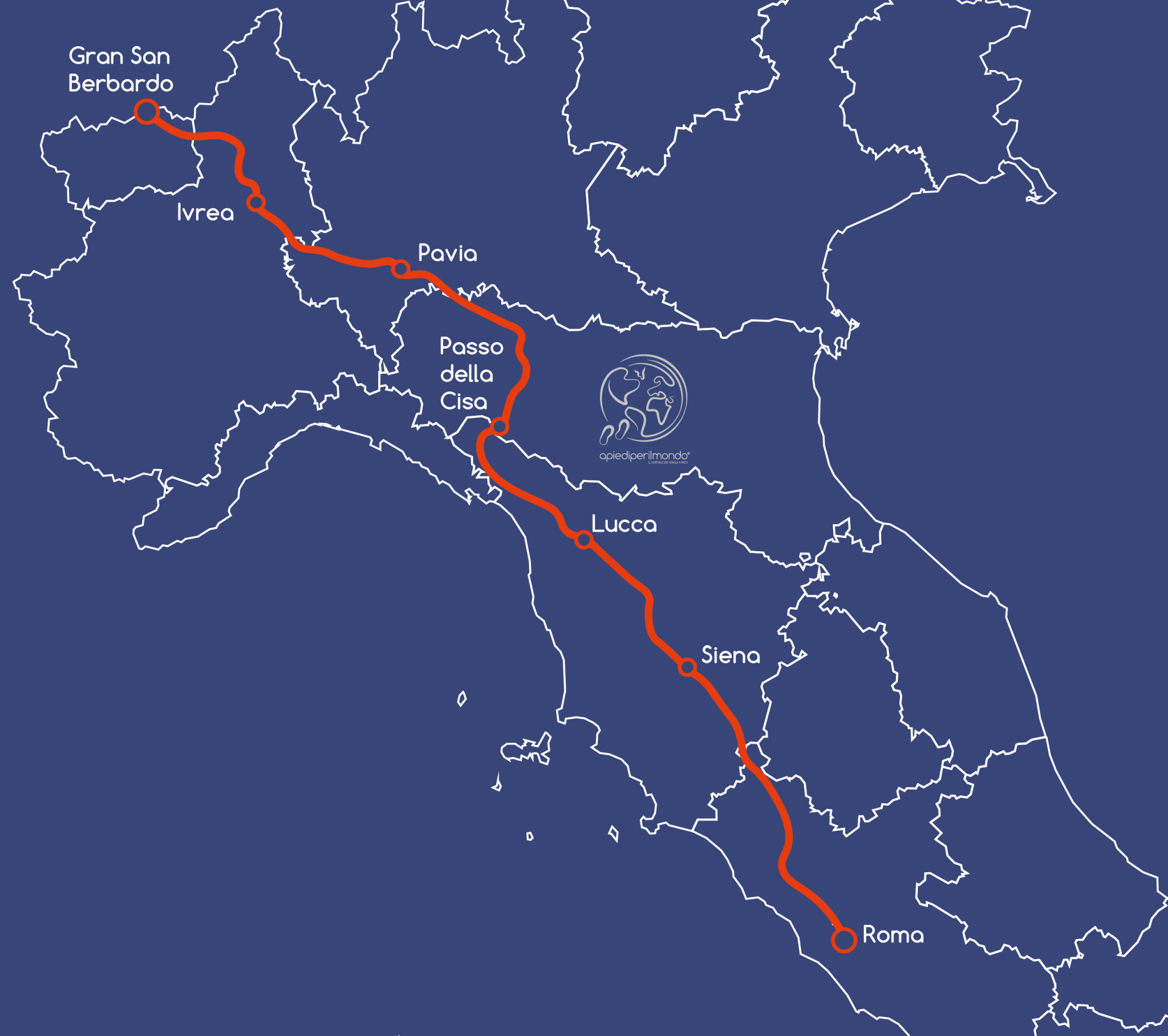
The Via Francigena in Italy covers a 900 km route divided into 45 stages, many of which vary in both length and difficulty. It crosses the country from north to south, revealing six Italian regions while passing through small towns and major cities.
Italy is, as we know, a remarkably diverse country—travel just 50 kilometres and you'll notice landscapes, food flavors, wine qualities, and accents changing dramatically. Walking along this spine means discovering all this cultural variety, hidden even in the smallest church encountered along the way.
Many people decide to complete the entire Via Francigena in one go, preferring the summer months for their time availability and favorable weather.
However, those without 45 consecutive days available can divide the route into different sections, using the larger and more important cities encountered along the path as starting points—both because they're well served by public transport and because they nearly always have significant artistic and cultural interest.
In recent years, work has also been undertaken to develop the Via Francigena of the South, which runs from Rome to Santa Maria di Leuca in Puglia. We'll dedicate an article to it as soon as more reliable information becomes available.
Below we provide a possible division of the Via Francigena in Italy:
From the Gran San Bernardo Pass to Ivrea, you can complete the descent from the Alps to the entrance of the plain.
From Ivrea to Pavia, you can walk through the rice paddies of the Po Valley plain, with the sensation that time stands still.
From Pavia to the Cisa Pass, you gradually begin climbing, touching what may be the most challenging section of the entire Italian Via Francigena, without ever reaching significant elevation gains.
From the Cisa Pass to Lucca, you reach the Tyrrhenian Sea, then arrive at one of Italy's most beautiful artistic cities.
From Lucca to Siena, you enjoy Tuscany with its flavors and the beginning of its rolling hills, reaching the city of Saint Catherine with its distinctive shell-shaped piazza.
From Siena to Rome, you walk through the Val d'Orcia with vineyards alongside, passing through Radicofani before entering Lazio, visiting Viterbo—the City of Popes—and finally Rome, your much-anticipated final destination.
We recommend continuing your reading to then move on to dedicated articles.
Landscapes Along the Via Francigena
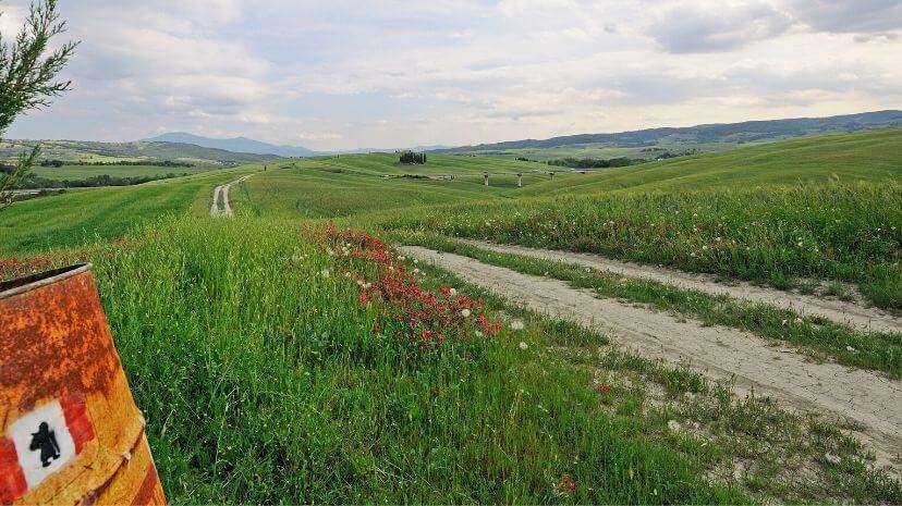
Along the Via Francigena you can find a variety of landscapes that change depending on the season, region, and latitude.
Consider how different beautiful Italy is—from the snow-covered Alps in winter, to the rice paddies of the Po Valley plain, to cultivated fields in Emilia-Romagna and the green forests of the Apennines; the Tuscan hills with their vineyards are no less remarkable, and the ancient profiles of thousand-year-old cities like Siena and Viterbo form a mosaic that easily remains in the heart of every walker.
Obviously, the season in which you choose to undertake the walk will characterize the colors that will compose the postcards presented to your eyes.
Each season will have its own special qualities, and it will be difficult to remain indifferent to the majestic nature that frames unforgettable memories in every pilgrim's mind.
Difficulty of the Via Francigena
As with any long-distance walk, minimal physical preparation is necessary to tackle the Via Francigena with greater ease and confidence. Although there are many flat sections, you need to be accustomed to walking regularly for prolonged periods.
Share
A Piedi Per Il Mondo
New articles on walks, trekking and hiking trips. Free, no spam.
Discover our itineraries
in Italy.
Via di Francesco from Assisi to Rome
Via Francigena from Lucca to Siena
Via degli Dei in 7 stages
Want a tailor-made itinerary?
Plan your trip