Rota Vicentina and Fishermen's Trail: Portugal's Most Spectacular Coastal Trek
Discover one of the world's most breathtaking coastal treks along Portugal's southwestern shores. The Rota Vicentina and its jewel, the Fishermen's Trail, deliver unforgettable landscapes and profound moments of connection with nature.

In this article
TECHNICAL DETAILS
- Start : Porto Covo (Setubal)
- Finish : Odeceixe (Aljezur)
- Distance : 75 km
- Stages : 4
- Surface : sand dunes, dirt tracks
- Difficulty : Leisure Hiking, LH
- Elevation Gain/Loss : +/- 730 m
Rota Vicentina: Historical Way, Fishermen's Trail and loop trails
The Rota Vicentina is today one of Europe's most beautiful and captivating walking routes. It winds through southern Portugal, between the Alentejo and Algarve regions, covering a network of trails stretching an impressive 450km.
It's divided into two main routes: the Historical Way and the Fishermen's Trail, both incorporated within the GR 11 (Caminho do Atlântico) and the E9 (European Trail that ideally follows the entire Atlantic coastal route from Portugal's tip to Estonia).
Let's explore these two variants in greater detail.
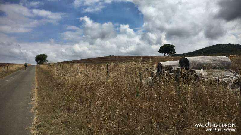
The Historical Way spans 230km. It begins in Santiago do Cacém, a small village in the heart of Alentejo, and ends at Cabo de São Vicente, exactly at Portugal's southernmost tip. Divided into 12 stages ranging from 12km to 25km, it reveals a far more rural side of Portugal, deeply rooted in the land and its ancient traditions. The route rarely encounters the ocean, only in a couple of places towards the end.
Unlike the Historical Way, which runs parallel to the ocean with minimal contact, the Fishermen's Trail is characterised by the constant presence of the sea. At 75km long and divided into 4 stages, it begins in the picturesque Porto Covo, a small fishing and tourist village just a handful of kilometres from Sines. It passes through the magnificent locations of Vila Nova de Milfontes, Almograve and Zambujeira do Mar, eventually reaching Odeceixe. An extraordinary experience but physically very demanding (covered in our difficulty section). You can view the Fishermen's Trail map here.
Part of the Fishermen's Trail concept are several loop trails, which branch off from the Historical Way throughout the Rota Vicentina, deviating seaward and returning to the starting point. There are 5 short loops in total:
- Odeceixe Beach Loop, 9km
- Amoreira Beach Loop, 6km
- Ponta da Atalaia Loop, 14km
- Portal da Carrapateira Loop, 10km
- Telheiro Beach Loop, 6km
There are also a series of shorter "orange" loop trails, some completely separate from the Rota Vicentina, others interwoven with it. Individually ranging from 3km to 16km, they cover a total distance of 90km. Their distinctive signage sets them apart, marked by the yellow-red double waymark.
Landscapes: Historical Way and Fishermen's Trail
The Rota Vicentina preserves truly breathtaking scenery, varying significantly depending on whether you're walking the Historical Way or the Fishermen's Trail.
On the Historical Way, for example, hikers are accompanied by endless cork oak forests, eucalyptus woodlands and fields of grain and fodder. The economy of the interior regions remains tightly linked to the land, with agriculture and livestock as the primary occupations. Unlike eucalyptus production, controlled by multinational timber giants, cork harvesting represents a valuable local resource. Walking through these vast cork forests is truly captivating.
A few fascinating cork facts.
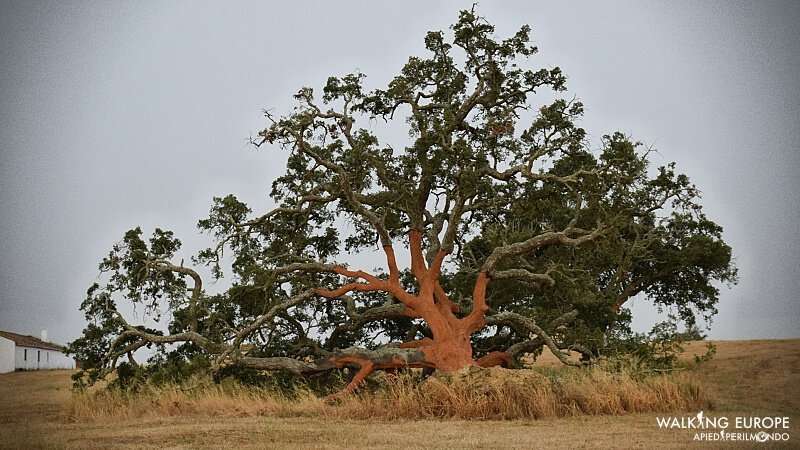
Portugal, particularly the Alentejo region, is responsible for 50% of the world's cork production.
Primarily used for wine bottle corks, it now finds new applications in construction as a remarkable insulating material.
The cork tree is known as the Cork Oak. Approximately 25 years must pass before the tree is ready for its first cork harvest, after which cork can be harvested every 9 years.
Extraction occurs between May and July and still requires skilled manual labour and the use of axes today.
Once stripped of its cork layer, the trunk reveals an astonishingly bright red colour, which gradually fades to brown over the years.
It's immediately marked with the year's final digit, ensuring they remember when the next harvest is due.
If you walk through the cork forests after "harvesting," you'll certainly encounter stacks of cork bark, a truly unique spectacle.
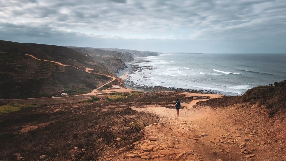
The Fishermen's Trail, literally the "Fishermen's Route", develops entirely along the Atlantic Ocean coast. The landscape is completely dominated by three colours: the blue of the sea, the gold of the sand, and the green of vegetation.
Endless sand dunes are interspersed with characteristic coastal villages, all just metres from the dramatic Portuguese cliffs.
Nature gifts us magnificent vistas. The rocks, sculpted by water, seem to have only recently broken away from the cliff face and tumbled into the ocean.
Paradisiacal but unreachable coves remind us that pristine, untouched nature creates forms and colours like nowhere else.
And the soft, fine sand is covered by a dense layer of hardy succulents, tempered by sun, drought and strong winds.
In the Portugal destination section, you'll find all our Fishermen's Trail and Rota Vicentina travel packages that we can customise for you and your friends.
Difficulty on the Rota Vicentina: Historical Way and Fishermen's Trail
The Rota Vicentina presents varying challenges depending on whether you're walking the Historical Way or the Fishermen's Trail. However, both routes share common difficulties:
- First and foremost, the heat. Given the high temperatures from June through September, walking during these months is not recommended. The best time is between September and May, when milder temperatures allow you to fully enjoy your walking days.
- Almost complete absence of facilities and refreshment stops between stages. You may frequently walk 15-20km before encountering a village, café, or even a water source. For experienced hikers this is no problem, though less experienced walkers might feel some anxiety.
- The lack of mid-stage facilities creates another challenge: the need to carry all provisions for the entire day, including food and water. This means a backpack at least 3kg heavier: factor in at least 1.5 litres of water, plus fruit, energy snacks, and perhaps a satisfying sandwich to recharge during your stage.
To this general framework, add some specific notes about each route.
Starting with the Historical Way. This presents no particular difficulties. Elevation changes are minimal and gradients are gentle. The landscape alternates between rolling and flat terrain, with the lowest point at sea level and the highest at just 329m. The route has no rough or difficult sections. It develops primarily on dirt tracks, with a very low percentage of asphalt.
Therefore a physically easy itinerary suitable for everyone, including less experienced hikers and those unused to long-distance walking. A Leisure difficulty level.
The Fishermen's Trail is quite another story. The difficulty level increases considerably, particularly from a physical perspective. Developing largely over sand dunes, the exertion is substantial. Walking on soft sand means your foot sinks with each step, you slip on climbs and feel every kilogramme of your backpack, not to mention the kilos of sand inevitably ending up in your shoes. Your walking speed drops from the typical 4.5–5 km/h to 2.5-3 km/h, almost double the time for the same distance.
Fortunately, elevation gains are minimal, just tens of metres.
The Fishermen's Trail develops across sand dunes beside magnificent cliff-edge scenery. If you suffer from vertigo, this could be challenging. You'll often walk beside sheer drops. But don't worry, it's manageable: at exposed sections you can walk parallel to the trail along a more inland strip, further from the cliff edge. The key is always keeping the waymarks and beaten path in sight.
Climate on the Rota Vicentina
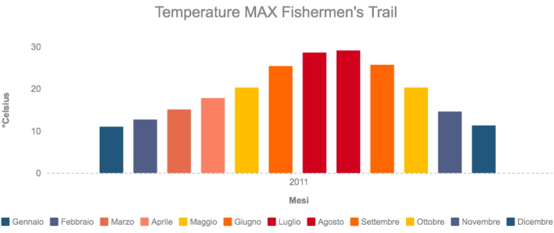
One of the difficulties I mentioned earlier deserves further attention: summer heat and the climate of Alentejo and Algarve throughout the year.
What's the best time to walk the Rota Vicentina? Looking closely at the graph of monthly temperatures and precipitation, we notice:
- The minimum temperature never drops below freezing – January is the coldest month with minimums above 4°C.
- Maximum temperature peaks in August at around 30°C.
- In summer, between June and September, the temperature range between minimums and maximums is very wide – in August, for instance, the minimum is 16°C.
- Rainfall is abundant year-round, except in July and August (10mm and 11mm respectively). Surprisingly, annual rainfall exceeds that of Milan, surpassing 1000mm.
The Rota Vicentina benefits from an oceanic climate. In summer, the heat is dry, not humid, and days are always slightly windy. In the evening, as temperatures drop, you might need a light jumper against the cool air. It's certainly ideal beach holiday weather, but for a hiker covering 20-25km, possibly on sand under the sun, it's far from perfect conditions.
The only positives of summer walking are long daylight hours and incredible light for photography.
Trail Waymarking on the Rota Vicentina

One thing you won't need to worry about on the Rota Vicentina is the waymarking – trust me, it's exceptional. Composed mainly of wooden posts at knee-to-waist height, it features efficient signboards near towns and painted marks on trees and rocks where posts are absent.
The painted marks are:
- Horizontal and parallel when indicating you should go straight.
- Form a 90° angle to indicate turning right or left.
- Form a cross at junctions to mark the wrong path.
One outstanding quality of this waymarking is its high frequency: you'll find a signal at most every 50-100m, so even if you lose concentration, you won't have walked kilometres before realising you've gone wrong.
The Historical Way and Fishermen's Trail differ particularly in waymark colours.
The Historical Way is marked with white-red waymarks. Passing through many forests, most signals are on trees at eye level. You won't frantically search for a mark – simply look straight ahead.
The Fishermen's Trail is marked with blue-green waymarks. As the route crosses dunes, the path is mostly marked with posts: no taller than your knee, before you crest a dune you'll spot the next one. My advice is to reach each post and, before taking another step, spot the next one, always maintaining a fixed point ahead.
The Fishermen's Trail also has a couple of special signs warning that no further waymarks will follow. What should you do? Keep going straight, always straight. No junctions, so zero risk of getting lost.
In the Portugal destination section, you'll find all our Fishermen's Trail and Rota Vicentina travel packages that we can customise for you and your friends.
Share
apiediperilmondo by wayure
New articles on walks, trekking and hiking trips. Free, no spam.
Co-fondatrice, Apiediperilmondo
I've been organising walks since I discovered that walking slow is the fastest way to know a place. I take care of every logistical detail so you can focus only on the steps ahead.
Profilo e tutti gli articoli di Deborah